Humboldt Peak
Date Climbed: 2/19/16- 2/20/16
Climbing Partners: Matthew, Gabriele, and Anthony
Elevation: 14,064
For more photos, follow me on Instagram or add me on Facebook:
drweiss2
Daniel Weiss

After a lot of preparation and some failed attempts on other peaks, I was ready for another try of Humboldt. I had previously visited the peak last winter and turned around due to avalanche conditions. This time I had planned to avoid the avalanche terrain and take the East Ridge route, the most common route up Humboldt in winter. But I needed some help. A good friend of mine, Matthew, and I met at a coffee shop to discuss details on a February attempt. After discussing some details, we soon had a plan and a team. We would meet February 19 at 4 AM and carpool to Humboldt, where we would set up camp at timberline and summit the next day.
There were two reasons for this: first, I knew it would be a long route, especially since we had no idea how well our team would work together. Second, The winds were predicted to be 70+ on the 19th. with an exposed ridge climb for an extended period of time on one of Colorado's windiest 14ers, our margin of error would be too small. So I deeply believed our greatest chance of success was to wait out the storm and make summit day as easy as possible. Plus, I just love winter camping.
With this in mind the 19th quickly came and our team of four climbers met in the parking lot the church I work at in downtown Denver. It was Matthew and I, Anthony (a friend of Matthew's), and Gabriele (a CCU student I invited to join). So our ragtag bunch threw our backpacks into the back of my truck and drove off into the darkness. By 7 AM, we were at the lower trailhead of Humboldt and the winds were horrific. Just opening the door to the truck was a feat in itself! Nonetheless, we were in high spirits with the warm temperatures and an adventure ahead of us. It took us about half an hour to get all of our gear together, and off we went down the road. Our pace was extremely slow with the winds in our faces, but we eventually made it to the shelter of the trees and donned our snowshoes.
Up we went, and quickly made it to the Rainbow trailhead, where our route would take us off the road and onto the East ridge. Even in the trees, he winds were uncomfortable and very loud. Even when we were feet from each other, we had to shout to hear. Slowly, the miles ticked by and we made progress up the ridge, occasionally getting glimpses of the lower east ridge above timberline. Even with a hard snow crust at higher elevations, plumes of snow could be seen on the mountain tops, which meant the winds must have been very strong to blow crusty snow. As we progressed, the slope angle became steeper and steeper, and soon we were stumbling through the now slushy snow up a very steep slope. Thankfully the avalanche danger was mitigated by the trees, and we safely passed our only worrying slope for the trip. Shortly after our steep slog, the trees began to thin and the wind became stronger and louder. Timberline was near, and soon we could see our ridge.
Our team was exhausted, and camp sounded like a welcome idea, even though it was not quite noon. But since our team had not done many winter camping trips, I knew we would be slower in setting up camp, and so we got to work. After digging out a very large, three foot deep shelter for our tents, began to pull them out of our bags. Since no one else had a four season tent, I volunteered my three season tent as tribute for the other half of our party. Out came the tent, and immediately the wind attempted to take it. Thankfully, our shelter somewhat protected out tent from the wind, and after a bit of work the tent was up and anchored in (as best as we could with the slushy snow). The second tent, my four season one, went much faster and it was securely anchored to the snow in no time. After fiddling with some of the anchors to make sure the tents would not be blown away we all dived into our respective tents and began to unpack.
First, off went the boots, then came the sleeping pad, the sleeping bag, the extra layers, and the kitchen. As we hunkered down and began to melt water, the sunlight durned from bright yellow, to orange, and the sun began to set. I left the tent door open so that the fumes would not build up in the tent and so that we could enjoy the awesome views of the mountains to our east. Although the winds were still unrelenting, the tent offered a comfortable shelter. Stars began to come out and our tent made dinner. After a satisfying meal of granola and stroganoff, we went to bed.
As the night dragged on, the wind howled more, and more ferociously, and I could hear the other tent's rain cover flap louder and louder. It was as though a jet plane was right above us the whole night and I began to worry that a storm was brewing. I pulled out my phone and managed to get some service, and looked up the forecast. The winds would remain constant until noon the next day, but I read some news that 148 mph winds had been recorded not too far from where we were. If that reached us, it would be fatal, even with warmer temperatures. I sent up a silent prayer and went back to sleep.
Early the next morning, we began to melt snow for our water and started discussing our plan. The winds had not gone away, but they were a little better than the day before. I just had to hope that the forecast would hold so that we could make it past the final ridge. Soon we had left camp and were moving at a quick pace. As soon as we had exited the trees, the wind howled at us. It seemed as though the mountain itself wanted to keep us away from the summit, pushing us back with all its might. We dropped the snowshoes and began our long walk along the wind blown rocks leading to the summit. The first major obstacle was a huge 1000 foot slope from where we would finally see the summit of Humboldt.
Every step was an effort, and even with the sun and high temperatures (relatively speaking), the wind was bitter and icy. We eventually had to pull out heavier layers, and I even had to put on my heavy weight gloves. After an hour of hard work, our progress still seemed minuscule, and the wind would not relent. Thankfully, I could just see the summit around the corner of the slope. The last bit would be more technical than before, but if the winds did not let up soon, we would not be able to make it. As the summit inched closer and closer, I felt stronger and soon even the wind began to die down.
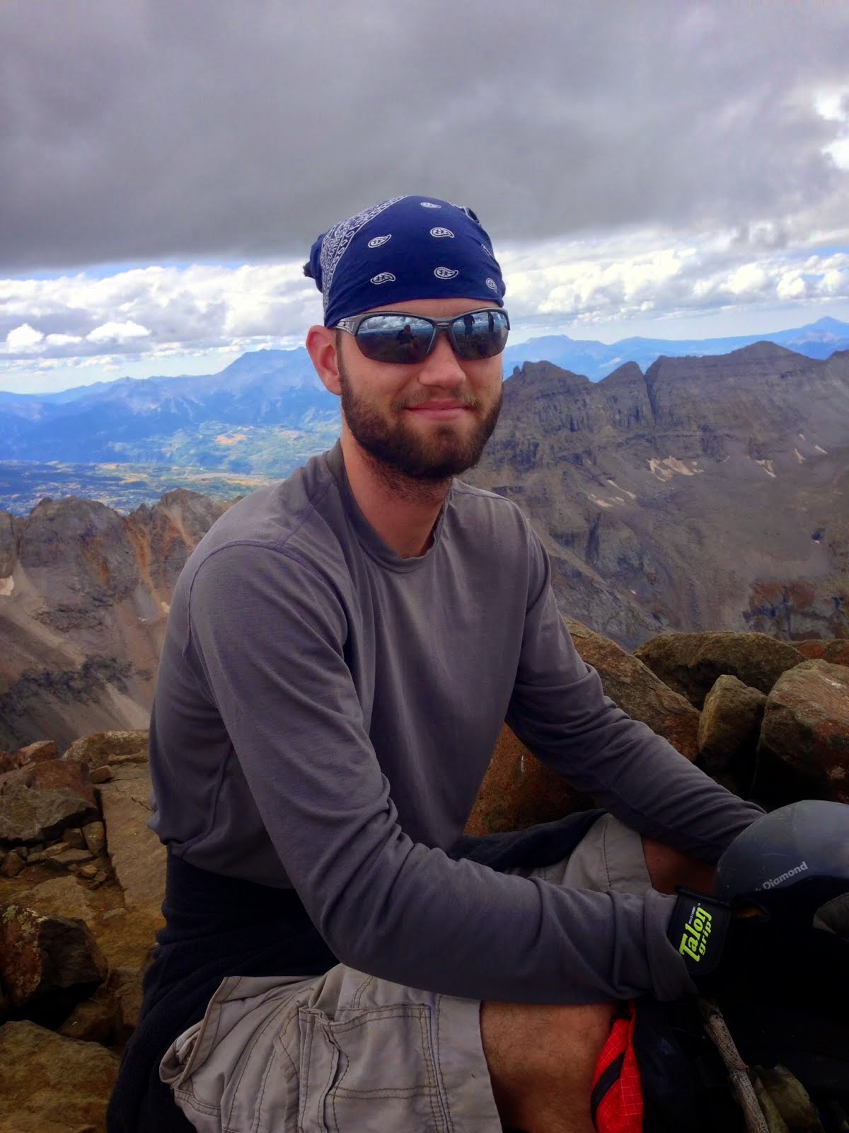
Progress across the flat part of the ridge went quickly, and we only had about 500 feet of scrambling above us. Up we went, climbing over rocks and around boulders, avoiding the huge drop off to our right. The others made it a minute before I did, but soon, there was nothing but blue sky above me and I knew I was almost there. As I climbed over the last step, the others came into view, all smiles. We had made it! The dramatic view of the Crestones alone was worth the trip. Off to our right was Kit Carson and Challenger, and to the left we could just make out the infamous Little Bear Peak.
After taking plenty of pictures and congratulating each other, we descended the ridge, going as fast as our tired legs would go. On the way down, we lost track of our snowshoes and had to traverse under a few worrying slopes until we finally reached them. We put them on and descended to our high camp. As soon as we were at our tents, Anthony flopped down on the snow next to his tent and I dove into mine, looking forward to a good lunch and some water. We took a quick rest and packed up our gear.
It was early afternoon by now, and we still had several miles to cover. Down we went through the now soft snow, slipping and sliding all the way. At last we reached the trail junction with the road and my knees finally had a break from the unending pounding of each step. The road went by quickly and as we left the trees, into view came one of the most beautiful sites (my eyes) have ever seen: my truck! A seat, some food and an easy drive home awaited us. As soon as we got there, we unloaded our heavy packs, hopped in the truck, and drove to Pueblo to find some food and unwind. By the time we reached Pueblo, darkness had fallen. We had some burgers, drove home, and said our goodbyes. Our mission was a success, and a winter calendar ascent had been won! On to the next one! And in two years, the highest summit in South America; Aconcagua.
Mt. Elbert
Date Climbed: 11/12/15
Climbing Partners: None
Elevation: 14,433
For more photos, follow me on Instagram or add me on Facebook:
drweiss2
Daniel Weiss
Second winter climb of the season. Although the snows stayed late last year, and summer did not seem to last long enough, I was ready and rearing for some snow climbing and skiing. It seemed as though nature wanted to reconcile the late snow last season, and thus the warmer temperatures than usual lately have led to more rain than snow so far. Although precipitation has been above average, the warmer temperatures have prevented significant snowfall until this moment. Just two days prior to my climb, a massive snowstorm blew through, adding over a foot of snow and changing the avalanche danger to moderate.
Having failed to climb Yale two weeks before this climb, I was determined to make up for it and summit Yale. With the new snowfall, however, I was forced to take a more stable route, and thus decided upon Mount Elbert. This way I could shorten up the hike and elevation gain, as well as knock off the Colorado high point off my bucket list all at once. So with a 4 AM alarm and a new jacket to test out, I set off into the heart of Colorado.
The sun rose just as I hit the trailhead. Unfortunately, my lack of 4-wheel drive and a low snowline forced me to walk up the 4WD rode, and so added a few miles to my journey. The road went by quickly and soon I had to put on my microspikes. Connecting with the Colorado Trail, I made a quick half mile hike over to the South Elbert intersection and began the steep trudge up the slope, which the Swatch range is so famous for.
The trail was easy to follow at first, as someone in snowshoes had obviously broken trail shortly after the storm. Not having snowshoes myself, I was worried that I had come underprepared (a mistake I often remedy by over-preparing). Although the snow coverage was no more than 4", I was sure that the snow above timberline would be a tough challenge. As the miles and elevation went by, the views became more and more spectacular. The dense forest was slowly replaced by open sky and a vast valley. Ahead lay rugged snow-capped peaks and (to my trepidation) enormous snow plumes, indicating a high winds and low temperatures. Just hours before my truck's thermometer had read -3 degrees. Although it was bright and sunny, the forecast called for temperatures reaching -22 degrees at the summit. Knowing this would be common come midwinter, I had made some purchases during the summer to deal with these extremes.
Among them were gloves designed for Alaskan peaks and a belay jacket designed for comfort somewhere in the -10 range. I even wore three layers of pants, which I only did when the forecast called for blizzard conditions. Thus, i was prepared for the worst it could throw at me.
As treelike came closer and closer, the wind began to pick up, and I knew that the cold would not be my only enemy. Just over a year before, I had battled 60+ mph winds on Democrat and the surrounding 14ers. The winds not only chilled me to the bone, but had forced me to slow down and even lay down when the gusts became too strong. If I had to do the same on Elbert in knee deep snow, I would be lucky to summit before dark, and there would be no backup on this trip. My only consolation was that I would have cell phone service almost every step of the way, so that I could call for help in an emergency.
By 9 AM I had reached timberline and decided to layer up and eat in preparation for the battle with the wind ahead. If it was as bad as it looked, I would not be able to sit down and enjoy lunch as I had planned, but would have to make a mad dash to the summit and back in a hope of reaching treeline before nightfall. What's more, the snow had steadily grown deeper and deeper. So much so, that the previous hiker had obviously given up a mile back, forcing me to blaze my own trail to the top. Although it may sound as though I had plenty of time until dark, it will become very clear just how slow one moves above timberline when winter comes. Just to give you an idea of just how tough it is, on a typical winter hike, expect it to take three times longer to reach a destination than in the summer in non-technical terrain. Although progress had been great (averaging 2 mph up to this point), things were about to screech to a halt.
As I set out from my shelter of trees full of a delicious Twix and water breakfast, a snow tornado came roaring down the slope. I turned away just in time protect most of my face from the stinging cold of the snow. Imagine, for a second, videos of Mount Everest where the snow is blown for miles from it's enormous summit. The sound of the steady roar of the jetstream and the majestic waves blown from it's pyramid. I had a very similar sight as I left the trees and the southeast bowl was laid bare before me, with just the smallest view of the summit miles away. Granted, Elbert is not nearly as intimidating, and the winds are much more tame, and the temperatures much warmer, but the beauty and challenge is still there.
Up I went, making good progress at first until I came to the first wind-loaded slope that led to the first false summit. Soon I was huffing and puffing my way up a small slope, making on step every breath or two, sinking in to my knees. If the rest of the ridge was like this, I wouldn't make the summit until nightfall if I was lucky. But since the weather was supposed to be good and there were very few objective dangers on Elbert, I was determined to make the summit, no matter how long it took. After half an hour, I had only made a few hundred feet of progress. I pulled out my ice axe for balance and began to push harder, hoping that the high winds had exposed the rock on the windward side of the ridge.
As I approached the top of this "small bump" on the ridge, I finally reached an island of rocks, allowing me to make quick progress over the hill. Although the summit seemed no nearer, I saw my saving grace: exposed rock on the north (right) side of the ridge. I counted 4 more false summits, put my head down and moved on. Every time I would reach the top of a false summit, I would set my sites on the next and remind myself that I only had a handful more. The second one went by quickly, and the wind began to diminish. The sun appeared to be chasing away the winds, and I could no longer see the long spindrift I had seen on my approach.
On the third false summit, I could see the faint outline of the summer trail switchbacking its way up the steep slope. This would be the real test. If I could make it to the top of this, all I had left was the summit slope. But this would also be the longest and steepest part of the hike. Although the trail was very easy to follow and I flew up the first half, the trail soon disappeared and as the slope began to level out, the snow became deeper and deeper. Whereas the snow was no more than a few inches deep on the lower half, I was now forced to find the path of least resistance and pray that the snow was supportive... which was not often the case. As I ran out of steam, I looked back over the ridge and the valley below me. Off in the distance was the small town of Leadville, Colorado's highest city. To my right was the gigantic southwest bowl and a frozen lake, and to the left were the treacherous Box Couloirs of Elbert. Directly below me was one particularly steep shoot, which I hoped would slide so that I could see a live avalanche. Sure I had read about and watched videos of avalanches, but I had never seen one in person, and hoped that the warm temperatures and heavy snowfall would release one just to add some excitement to the journey.
Surprisingly, the temperatures were much warmer than predicted (although they were still well below freezing), and I was forced to shed my jacket. After a few more minutes of wading through the snow, I leaned into the slope and sat down. I needed water and some food for energy. Taking in the beautiful scenery before me, I pulled on my jacket again and felt thankful that I did not have to race to the top as I would during the summer. No thunder in winter! Suddenly I saw movement in my peripheral view, and turned to stare directly at it. A tiny black dot was making quick progress up my trail. I was not alone. I had enjoyed the solitude earlier that morning, but was relieved to know that someone else would be nearby to help if I were to twist an ankle or something. Being so close to the summit, I took a longer break than needed, waiting for my companion to join me and hoping that he or she would be just as glad to share the days first summit together.
After a while of waiting, I decided that this person was moving so quickly that I would be better off just breaking trail most of the way as they were obviously moving faster than I. just as I made the push to the 4th and last false summit, my heart sank. Away in the distance ahead and a little higher, there seemed to be even more false summits. I had already been at it for 5 hours and still had to get down. But it would be a waste to stop this close, and so on I went. The route-finding was awful and progress was slow, but the summit came steadily closer and closer. Just a few hundred feet of the top, my companion caught up with me. Looking back, we made eye contact and nodded to each other. We were both exhausted and agreed that we could talk on the summit if there was any shelter to be found.
I dawned an extra jacket, gloves, and my baclava anticipating a blast of icy wind upon summiting. Lo and behold, my efforts were not in vain. As my partner broke trail the rest of the way, I came up close behind and was greeted 1) with a spectacular view of the Swatch and Aspen ranges and 2) a blast of arctic wind that instantly froze any water that was exposed. My nose instantly began to run and then froze, and my water bottle quickly turned into a chunk of ice frozen shut. We made unbalanced progress the last dozen steps to the top and made our congratulations. My eyes watered from the cold and I quickly regretted not equipping my ski goggles before the summit. I took some quick pictures and a shot of myself on the summit as evidence, and asked my friend where he was from.
I instantly realized why he had caught up so quickly. Not only was he from Leadville (living at twice the altitude of Denver), but he was quite obviously a trail runner. Fast and light is a trail runners motto, and I could tell he was freezing in the icy wind, with nothing but a shell jacket and thermal pants on over breathable shoes. Good thing is he could make it up pretty quickly. Bad thing is if something went wrong and he was forced to spend any amount of time in the dark, there would be no chance of his making it through the night. It is the polar opposite to the style of climbing I do; slow and steady. Safety and preparation for every scenario. After a quick exchange, we began the descent. Not wanting to blow out a knee or ankle, I did not event try to keep up. I was already losing feeling in some of the toes on my right foot, and had no intention of spending a night out because I rushed and hurt myself. Far below we could see another hiker making slow progress up the slope.
Half an hour later, a miserable looking young man carrying an unnecessarily large pack stood before me. It had taken him 6 hours just to reach this point, and he still had another hour to go (if not more). It was already close to 2 PM and the sun would set at 4:30. This meant he would be lucky to make it back to timberline by 4:30. Although it was warm right now, the minute the sun disappeared, the temperatures would drop rapidly and things would get dangerously cold. He told me he had come from San Diego just yesterday. I asked how he felt. Dizzy and exhausted; classic Mountain Sickness, which can have life threatening consequences. Although we were not really that high, the altitude difference and energy required to move at this elevation could cause over-exertion and could cause and edema. That being said, he did not appear to be in that bad of condition, and was probably just tired. He asked how much longer, and did not appear happy with my response. He then asked if I thought he should go on. I explained that the only thing stopping him was his condition. The weather would be good, even after dark and asked him if he had plenty of water, food, and a light. Yes to all three, so I wished him luck and told him just to carefully follow our trail on the way back down. He decided to continue up and we went our separate ways. Going down went much quicker than going up, although my knees were throbbing when I finally made it to the upper trailhead. A quick dash back down the road and I was in my tuck and on my way home.
Another 14er down and still a lot to go. But I felt confident that I could handle whatever they could dish out and a 4th class 14er with snow wasn't sounding too crazy after all. Elbert was nothing more than a long walk. It was the technical demands of climbs like Wetterhorn and Dead Dog that peaked my interest now. For a real mountain, a high camp, some technical axes and crampons, a rope, and luck would be all I needed for success. So what was next? Sangre De Cristos and their infamous Crestones or a long committing journey to the deadly Elk Range, with no safe climbs but all the adventure a mountaineer could want.
Wetterhorn Peak
Date Climbed: August 12-13, 2015
Climbing Partners: none
Elevation: 14,015
For more photos, follow me on Instagram or add me on Facebook:
drweiss2
Daniel Weiss
Having spent all day letting my heels recover from the blisters I had recently acquired from my ruined boots, I thought my best option would be to rent a cabin, wait out the coming storm, and clean my sores. It wasn't until 7 or 8 PM that I finally found a place cheap enough for my budget. Recommended by a local shop owner, I walked in to the "front office," sure that there would be no rooms available. As I walked in, I was greeted by two men, both talking about the Bible and drinking some whiskey with a roaring fire next to them. The scene is difficult to picture unless you saw it, but the "front office" was really just a small room connected to a cabin where the owners stayed when the hotel was open in the summer season. The men invited me in and asked if I wanted some cookies and whiskey (it was a very awkward but funny way to check into a hotel).
The owner was very kind and said that he had been expecting me, after talking with the shop owner who had recommended me, who happened to be his wife. Apparently, my predicament was not uncommon. Many people would have the same problems when coming through on their way to complete the Colorado Trail, and would often stop by to drop off trash and restock on food. He generously gave me a discount (something like 50% off) and gave me an entire cabin to myself. He had done the 14ers in the area and was impressed that I had traveled so far alone and had camped up in the basins alone as well. In his words, "that's real adventuring."
As I moved my stuff into my cabin, I looked up at the night sky. With a flash and a loud rumble, I could see where the storm was hitting furiously against Wetterhorn. I was glad I would not have to stay a night up at altitude while everything got soaked and having to deal with a thunderstorm alone at night. I got into my cabin just as the rain began to pour down. The shower was almost as interesting as the check-in; having no soap provided, I had to use the hand soap dispenser next to the sink. Although, this was much better than having no shower at all for the whole week as I had planned. Having cleaned my heel properly, I finally got to bed with the sound of rain roaring down and thunder in the distance, and was out before I knew it.
I was up early the next morning, running around town to get some supplies to protect my heels as well as a good lunch before I backpacked into Matterhorn Basin. Around noon, I arrived at my four wheeler, thankfully right where I had left it the day before. Although a bit wet, it worked just fine and after a quick but bumpy ride over to the Wetterhorn trailhead, I was on my way up to my campsite. I had hoped to camp right at the base of Wetterhorn and Matterhorn, but the forecast told me that there was a good chance of thunderstorms tonight, so I would have to stay around timberline. It took around an hour to get from the trailhead to the intended campsite. Unfortunately, there was another tent pitched there, and the only other suitable site that was close enough to water would be a good distance back down the trail. Approaching the tent cautiously, I called out, hoping that the hiker(s) would be ok with me setting up nearby. After hearing no response, I assumed that they were on their way back from a hike.
After a bit of deliberation, I figured I'd rather take my chances with having some upset campers and figured that even if they were angry at me, there would be safety in numbers. Although I enjoy backpacking alone, it's always nice to know there is someone nearby who can help if something goes wrong. With this in mind, I set up camp just far enough away that the campers would not see me. After a short nap, I heard the campers return. After a quick chat with them, I found that they intended to head back down, so I would be camping alone that night. As pretty as this location was, I would enjoy the solitude. After a few hours, I are bored and decided to have some dinner and check out the basin a little more. I had a clear view of Matterhorn from my tent, but could not yet see Wetterhorn, which was up and to the left around another mountain from the front door of my tent. After a quick stroll further up the basin, I returned and warmed up some Ramen.
It was almost dark by this time and I could see the clouds rolling in. I quickly cleaned my cookware and ran to the stream to fill up the bottles. Just as I began to filter the first liter, I heard a rumble off in the distance. My heart began to beat faster. I couldn't stop now, I needed this water if I was going to have enough for tonight and tomorrow. After a minute or two, I heard another rumble, this time much closer. I could tell now where the storm was rolling in from, and knew it could be on me in minutes. I quickly filtered my second liter and ran back to my tent, hoping tonight would not be like the last. As I huddled in my tent and stripped down for sleep, I could hear the rain begin to fall. It was not much, but I was anticipating a full blown storm again. Somehow, the storm I was anticipating, though, never materialized, and I slept fairly well that night.
The one complaint I had was my water. Every time I took a sip, I got the irony taste of what I thought was blood. Assuming I had just cut my lip, I continued to drink, and waited for my alarm to signal my ascent.
4:30 AM came quickly and I had all my gear on in less that 15 minutes. It was pitch black outside, and I could not see any stars. I assumed this meant that there were thick clouds and so took a 30 minute nap to see if the weather would change. By 5:30, I could finally see stars and looked up the basin to find that some climbers were already well ahead of me. I jumped out of my tent, brushed my teeth, and set off after them. In all honesty, the biggest reason I had stayed in my tent was because of my fear of mountain lions. If I have a partner, I don't worry too much as they almost never attack people in groups. But alone in the dark, and being the first one up the trail that day did not sound like too much fun, and I didn't like the risks. Especially since this was a Wednesday, which is one of the least crowded days on 14ers. But having seen other headlamps, I was encouraged and set off. The other hikers were over an hour ahead of me at an average pace, and so I made it my goal to beat them to the top, just to avoid any chance of running into any thunderstorms.
As I began my steady hike up the trail, I still tasted the iron in my water. I looked at the bottle with my light shining through it and saw no indication of blood. I wiped my lips with my finger and found no cut. That meant that there was something in the water that my filter had failed to catch. I suddenly remembered that the rock I had filter next to was a clay colored rock and came to the conclusion that I must have filtered my water right next to an iron deposit. I knew nothing about minerals and assumed that it could be harmful, so I would only drink the water when it was absolutely necessary, hoping that this was normal to have a lingering taste even after filtering.
I made quick progress into the upper basin and got my first glimpse of Wetterhorn Peak in the early morning alpenglow. It looked very close, but it also looked very challenging. The only official class 3 climbing I had ever down was on Dead Dog, and that was in snow. The real worry for me, though, was the exposure. Out of all the 14ers, Wetterhorn's standard route has one of the highest exposures. Well, I was about to find out, and I pushed even harder, hoping to be a the sun to the ridge. I had saved every picture available of the path ahead on my phone, just so as not to get off trail and to avoid getting stuck on any class 5 rock which was lurking close by. I could now make out the individual climbers ahead of me, and they seemed to be having some trouble route finding.
With my phone in hand, I made quick progress through some of the trickier sections and was soon within earshot of the hikers. I came to the first crux of the climb and found the climbers around a corner about 100 feet above me. They shouted down that they were lost and asked if they were going the right way. Looking around I found a cairn off to their left and told them to make their way over to that. As I began to ascend , I soon found that I had gone off trail, and made a quick move over a large bolder over to where I had last seen the hikers. I was actually having fun, and I found that this class 3 stuff made the climb a lot more fun than walking! I quickly climbed my way up to the "decision point," where I could either take the ridge or traverse below it. I opted to take the more difficult, but safer route and traversed. After some scrambling I was in an unexpected level areas just a few hundred feet below the summit. I found the V-notch I was looking for and climbed through.
At last, here it was. The 200 foot "staircase." The reports were right, it was hand-over-foot, but the holds were sold. It was like climbing up a ladder made of rocks. Looking to my left, I saw the drop that the reports had mentioned, but I realized that I had had much worse exposure on Mount Evans and Missouri Mountain. Everything looked ok, and it would be an easy climb to the top! The only worries I had left were that the other hikers might be just out of site and accidentally kick a rock down on top of me. I waited a few minutes sitting in the notch, and waiting to make sure that they had reached the top. After I was sure there were no rocks coming down, I dropped the 10 feet or so to the stairs, landing slightly unbalanced, but safely. I quickly began to move up the face, making sure that every hold was solid. In less than 10 minutes, I made the last move and was standing on top of a rather large plateau. I smiled at the couple who were sitting there eating their breakfast and taking in the views of Matterhorn and Uncompahgre.
Congratulations were in order and we took the mandatory summit pictures. There was not a cloud in the sky, and I knew we would be able to take our time on the way down. The couple were a bit nervous about the first part of the descent, since we would be climbing down ledges rather than up, and I understood their concerns. Most accidents occur on the way down. But I took the rope out of my bag and brandished it before them. "If we get in a bad spot, no worries. I've got a harness and some rope." They smiled and we all relaxed a bit. After agreeing to get down the difficult part together, we started down. Thankfully, we never felt uncomfortable enough to justify the rope, and so made quick progress past the stairs, and back up through the V-notch.
We decided to take the ridge rather that traverse on the way down, as it would be slightly easier. Once past the decision spot, all we had to do was follow the trail down the ridge and down into the basin. On the way down, we passed a few climbers on their way up, wishing them each luck. I told them to turn earlier than they thought so that they would avoid the same mistake I had made.
Once past the groups on their way up, our group began to talk about some of the climbs we had done. Both had done numerous 14ers, although the woman had done a few snow climbs. I immediately began to convey my love for snow climbs and my intent to climb Aconcagua. Both were very interested, so I told them of what I had planned so far. Both did not have the time to join, but wished me luck on my expedition. AS we entered the upper basin, our conversations began to wind down and soon we were hiking in silence, each lost in our own world of thought. After almost no time at all, we reached my high camp and we went our separate ways.
It took an hour to pack up, and I set off down the trail, eager to reach my 4wheeler and get some food. By 11 AM I was back in town, trying to decide if I had time to reach make a high camp for Sunshine and Redcloud. By 2 PM, I had communicated with my family that I had made it and told them of my intended destination. I set out, four-wheeler loaded, and began the journey south. Just before 3 PM, I had my four-wheeler unloaded and began the long ride up to the trailheads for Sunshine, Redcloud, and Handies. This road was much rougher than the one leading to Engineer Pass. It was a long drive, crossing many avalanche paths that had torn the road apart and exposed many rocks. When I finally reached the trailhead for Sunshine and Redcloud, I decided it was too late. It would be dark before I had reached my intended campsite, and so decided to take my chances with an attempt on Handies.
I set off up the road, which became even worse. By the time I reached the half-mile turnoff for American Basin, the road was nothing but loose rock and a little dirt (which is a nightmare to drive on). I made slow progress, and could tell that I would not be able to outrun the storm clouds that were closing in. By this point, the road was well above timberline, and it was very exposed to the weather. I decided not to chance it and would figure out something back at the truck. I made a tricky U-turn and began down the road a bit too fast. Just as a Jeep came into view, I hit a large rock which threw my handle to the left, and right into another rock. I was thrown from my ATV and, which kept on going, right off the edge of the road. I yelled out in horror, hoping against hope that my $4000 ATV had not gone off a cliff. I got up and ran to the edge of the road, just in time to see it run headfirst into some willows, where it came to a stop. I breathed a sigh of relief. Now all I had to do was find a way to get it out.
The jeep driver got out of her vehicle and came running, asking if I was alright. Frustrated, but alright. Although I had almost broken my ankle when the ATV began to flip, it had been saved when I was thrown from the ATV. We ran down to try and pull it out, but the slope was too steep, and I could not drive it out. I went around the willows to see if I could drive it through to the bottom where there was an old road, but just below I could see a 20 foot cliff that would surely destroy my ATV and me if I went with it. The only option left was to winch it up, and even then I would need another ATV as the road was too narrow to allow a jeep to park sideways.
Thankfully, the two ladies who were in the jeep offered me a ride back to my truck and I gratefully accepted. This was not the first time I was in debt to some passers by. On our way down, we stopped every ATV we came by, asking if they had a winch. Since it was so late in the day, we had very few to choose from and none of them had one. After two hours of rough driving, we were finally back at my truck. I tried to offer the ladies some money, but they refused and wished me luck. I unloaded, and drove through north again.
This call would take too long to text, and since I had no service in Lake City, I would have to drive north until I could get service. It took me an hour just to get to a location where I finally had a signal. I immediately pulled off to the side of the road and called my parents, who were the only ones close enough that would have some kind of winch and an ATV.
The call was brief, but a decision was made. It would take too long to reach Lake City from their location. So I had to drive another 3 hours around the mountains all the way to Ouray where I would spend the night, and then continue on to Silverton and meet up with them. From there, we would take the ATV's over Cinnamon Pass and winch out my ATV. Tired and frustrated, it was already close to sunset and I had to drive another 3 hours before I could get food sleep. Thankfully, my parents said I could get a room if I could find a hotel rather than having to backpack into a place in the area so I could camp for the night. My plans were ruined. Instead of the seven 14ers I had planned on getting this trip, I would be lucky just to get three. It's obvious now that God was teaching me patience and humility. Especially since I had come into this journey "prepared for anything". I had enough gear to deal with snow, rock climbing, rain storms, below freezing temperatures, bad roads, and even a gun for protection from wildlife. But I did not prepare for losing my ATV. Even after all these precautions, I still had to learn to trust in the help of others. So I got back on the road and began the long trip to my favorite town in Colorado; Ouray.
Mt. Lincoln
Date Climbed: 6/22/15
Climbing Partners: Katie and Charlie
Elevation: 14,286
For more photos, follow me on Instagram or add me on Facebook:
drweiss2
Daniel Weiss
Just as winter began to set in here in Colorado, I attempted the DeCaLiBro. This is four 14ers in one day; Democrat, Cameron, Lincoln, and Bross. Unfortunately, I was ill prepared that day, and only got Democrat, Cameron, and Bross. With frozen water, no traction (crampons or micro spikes) for the snow, and winds around 60+ mph and no gloves, I doubt I would have made all four without injury. And for this reason, I returned to Kite Lake to finish off this part of the Mosquito Range.
We had a late snow this year, which delayed my attempt until I could drive all the way to Kite Lake. Finally, after watching the conditions reports daily, the report came in that the road was clear. I arrived just below the trailhead around 7 AM with clear skies and a great forecast. It would be clear and warm weather with only a light wind. This was a nice change from the bitter cold of winter and lightening storms I'd encountered on Bierstadt. All the same, I prepared for freezing temperatures and brought along all the gear I might need. I wasn't going to be turned around this time because of lack of preparation.
I hit the trail and made great time. Kite Lake was still frozen but flooding around its edges with all the rain and snowmelt. What had been a simple hop across the creek just months before was now a river crossing, hopping from one rock to the next to avoid getting my feet soaked. One of the major differences between winter and summer is the speed you can travel. In winter, it could take anywhere up to 7 hours or so to travel a distance of 3 miles. In summer, it would only take 2. Summer was finally here and I was glad to have a lighter load.
Although the trail was mostly dry, there were a few snowfields I had to cross, and even took out my ice axe to be on the safe side. On my way up, I passed two girls whom I noticed did not have an ice axe. Although they had walking poles, it might be hard to stop yourself if you were to slip even with poles. So I decided to slow down a bit and make sure they didn't slip or anything. I was surprised to see that they were keeping up with me even on the slick snow. Once in a while they would stop and look around, probably to evaluate the snow and look for the best way up. At the time I didn't realize it, but they had on micro spikes, which allowed them to get good traction along the snowfields, whereas my boots would slip every so often. Either way, I decided to hang back just to make sure nothing happened. As I made my way out of the lower basin around Kite Lake and into the Upper Basin, I decided to sit down and take a break since there was no need to rush on such a nice day.
Shortly after I had sat down, the girls caught up to me. I asked which 14er they were aiming for today, assuming they were going to hit Democrat like everyone else. They were, however, going for Cameron and Lincoln, just as I was. With DeCaLiBro, there is a trail junction where everyone going to Democrat must turn left and all of the other 14ers are off to the right. This means that if you are going for all four, you have to go up democrat, come all the way back down and go back up to Cameron in order to reach the other 14ers. For us, however, we only had to go over Cameron and take a short walk over to Lincoln. In other words, we were going the same direction. Since it was a nice day so there was no hurry and since we were going the same way, I asked if I could join up with them.
They agreed, and off we went. I was just glad to have some company. As we marched up the slope, we introduced ourselves. Katie had recently moved to Colorado and had already completed a number of 14ers, while Charlie had only completed a few. It was obvious that Katie knew quite a bit about mountaineering so I asked about some of the mountains she had climbed. To my amazement, she had been to South America and climbed a high peak down there, as well as some mountains in California, Alaksa, and elsewhere. She also turned out to be a descent rock climber. At first I had thought they were only some young ladies enjoying a nice hike. It was obvious now that Katie had much more experience than I did and I began to ask question after question about her adventures and where she'd been and what she'd done. I had watched all kinds of movies about mountaineering overseas, but it was pretty cool getting to talk to someone who had actually done it.
Hearing about her adventures made me slightly jealous as I have always dreamed about climbing in the Andes and doing some snow climbs in Alaska. As much as I have dreamed of it though, she had already done it. Although I have a few expeditions I am currently planning for next winter, none of them are like an expedition to the Andes or Alaska. It was exciting to meet someone else who had the same interests in climbing big mountains.
Time seemed to fly by and we were soon approaching the summit of Cameron. Up until that point, the wind had been calm (unusual given my last experience here). Soon, however, the wind began to pick up and push us slightly off balance as we walked on toward the summit. Although it was nowhere near as bad as last time, it was still annoying and a little chilly. Just as we summited, the wind became constant and strong. We had to yell to hear each other even though we were only feet away. Neither of the girls had gloves, so I knew we couldn't spend a long time in the wind (I had done the same thing and had lost feeling in my hands for a good couple of hours last time). I noticed we were standing on a snow bank and gestured to the other side. I crossed over to the other side and sat down behind the cover of the snow. The others followed and we began to add some layers. Katie said that her hands we ok, but I could tell Charlie was cold, so I handed her the inner linings of my gloves. After we had warmed up, we pulled out some food for energy and discussed moving further.
I already had my mind set; even if the others decided to turn back, I was going to get Lincoln in. I had prepared properly for the wind this time, and I wasn't letting anything stop me this time. It looked a long way off, but we wouldn't have to gain too much elevation now, which was great news. Katie was up for it, but Charlie was very tired. After a moment, she said that she was ready to go for Lincoln. We packed up and set off at a quick pace, hoping to get through the wind as quickly as possible. As we began to descend to the saddle, I was expecting the wind to pick up even further. Surprisingly, it became very calm, and I almost began to sweat with the added layers. I took off my gloves and unzipped my jacket vents. In just over 20 minutes, we summited Lincoln, and I had finished my 14th 14er!
After taking the obligatory summit photos and another quick snack, we began the long walk down. Unfortunately, we would have to gain a little elevation on the return, and after such a long time of rest, it was much harder to start another uphill slog. I felt much slower this time, but still not terrible. On our way down, we saw a man moving up the Democrat slope. He was making extremely slow progress. It was so slow at one point that I almost wanted to go up there and make sure he was doing alright. However, we decided he was still moving and there were others descending past him, and so moved on. We passed a few other groups on the way down, and were quickly back at our cars. Relieved to be done, we said our goodbyes and began the long drive back to Denver.
It was a relief to have DeCaLiBro done, and it was obvious it was time to take my climbs up a notch. So as I drew closer to Denver, I began to set my eyes on Torrey's Peak and it's classic Dead Dog couloir. I also began to plan a few expeditions to Long's Peak and the Grand Teton. It was time to try some more challenging peaks and hope that success there would give me the confidence I would need to one day take on a peak like Aconcagua and Denali. The 14ers are still my goal, but I am beginning to think I may have a shot at some of the Seven Summits. Only time will tell, but if God opens the door, I hope one day to achieve some of these summits, and maybe even Everest! But for now, Dead Dog was my goal, and it was time to start preparing.